Tuesday, September 13, 2011

The Xingu River, Amazon Basin, Brazil


The Xingu River, which flows within the Amazon Basin of central-eastern Brazil, is shown in this Envisat image, which highlights the contrast between the rainforest and sprawling urbanisation.

The Xingu River flows northward approximately 2 100 kilometres from the Brazilian state of Mato Grosso into the Amazon River, the second longest river in the world after the Nile. The rivers that form the Xingu River are: Jatob , Ronuro, Batovi, Kurisevo and Kuluene, which is the Xingus main tributary.

Rapids and falls are plentiful, spanning 644 kilometres long, in the upper part of the Xingu, making only the lower portion of the river navigable. The river passes through partly unexplored country and is a rich area in terms of environment and cultural diversity, with some 14,000 indigenous people from nine different ethnic groups living along it.

In an effort to protect the indigenous people, the Xingu National Park, an area of 26,000 square kilometres, was created in 1961. The park has allowed 14 different tribes that were previously warring to learn to live together. But according to the Kaxi Amazon News Agency, ranchers and loggers have encroached on the park and threaten to pollute the river.

Last month Brazilian supermodel Gisele Bundchen endorsed a campaign by the Socioenvironmental Institute to protect the rain forest along the Xingu River from deforestation and pollution. The campaign is called Y Ikatu Xingu, which means clean and good Xingu water, in the native Kamaiura language. According to the Kaxi Amazon News Agency, Bundchen will tell the world that the Amazon's waters are in danger.

The Tapaj�s-Xingu moist forest ecoregion lies between the Tapaj�s, to the west of Xingu, and Xingu rivers and is home to over one hundred and sixty species of mammals and more than five hundred and fifty species of birds. However, the Transamazon Highway traverses this area and has increased the level of urbanisation, timber extraction and gold mining.

Urbanisation has increased all over the world with people moving away from rural areas to towns and cities. Brazil has a relatively high level of urbanisation with an estimated 8 out of 10 people living in cities roughly 144 million out of 180 million.

This growth needs to be monitored to ensure it proceeds on a sustainable basis, does not damage environmental resources and does not worsen the quality and life and safety of urban dwellers. The sheer scale of cities can make this difficult to achieve at least from down here on Earth.

Earth Observation-derived maps of land use change show how cities expand over time. Such information products are valuable to governmental organisations as well as conservation groups. In the field of risk management, satellite imagery can characterise urban environments to a degree of accuracy simply not available on the ground.

This 30 May 2006 image was acquired by Envisat's Medium Resolution Imaging Spectrometer (MERIS) working in Full Resolution mode to provide a spatial resolution of 300 metres. The image has a width of 462 kilometres.

French Guiana, South America


This rare, almost cloudless Envisat view of part of the northeast coast of South America stretches from the mouth of the Amazon River in Brazil to the territory of French Guiana, from where ESA's Earth Observation satellite was launched in 2002.

The coast is surrounded by a muddy-yellow plume of suspended sediment that issues from the Amazon River, by most measurements the greatest river in the world. The Amazon and its 1100 tributaries drain 40% of the entire South American continent. The River is responsible for 20% of all the freshwater discharged into the ocean from Earth's land surfaces.

Sediment carried all the way from the slopes of Andes is transported to the maze of channels making up the 270-km-wide mouth of the Amazon. Around three million cubic metres of silt is discharged into the ocean each day a daily volume greater than that of Egypt's Great Pyramid.

To the west is located the French overseas department of French Guiana, its border with Brazil demarcated by the Oyapock River. As an integral part of France, French Guiana is therefore the largest part of the European Union located outside Europe.

It was first settled by France in 1604 and was the site of penal settlements until 1951. In 1964 France chose Kourou in French Guiana as the site of its satellite launch base. Today the Centre Spatial Guyanais (CSG) is jointly supported by ESA and serves as Europe's spaceport. Kourou is located on the coast at about the middle of the image.

Some 90% of French Guiana remains covered by tropical forest and woodland, with its 195 506 inhabitants concentrated in low-lying coastal plains. There are 817 kilometres of highway in the territory but more than 3760 kilometres of navigable inland waterways.

This image was acquired on 16 October 2005 by Envisat's Medium Resolution Imaging Spectrometer (MERIS) in Reduced Resolution Mode, providing a spatial resolution of 1200 metres and an image swath of 1170 kilometres.

Monday, September 12, 2011

Bohai Bay, China


This Envisat image shows parts of the Hebei Province, the Tianjin Municipality and the Bohai Bay of the Peoples Republic of China.

Tianjin, China's third largest city, and Beijing, China's capital city, are located in the centre of the Hebei Province, but they are not part of it. The province borders Liaoning to the northeast, Inner Mongolia to the north, Shanxi to the west, Henan to the south and Shandong to the southeast.

Tianjin, located west of Bohai Bay (120 kilometers southeast of Beijing), is a prosperous city of 10 million inhabitants, surrounded by fertile farmland. Located between Beijing, to the northwest, and the Yellow Sea, to the southeast, the Tianjin Municipality has played an important part in Chinese history.

The city of Tangshan, located in Hebei 200 km east of Beijing, is situated to the north of the northernmost tip of the Bohai Bay curve. In the early hours of 28 July 1976, the deadliest earthquake of the twentieth century hit the sleeping city of Tangshan. With a magnitude of 7.8, the earthquake killed over 240 000 people and injured some 600 000.

China has a history of natural disasters, such as floods, droughts and landslides. Earth-observing satellites are particularly useful for tackling and monitoring environmental phenomena in China, the third largest country in the world, because of the countrys sheer size 9.6 million square kilometres and various types of terrain.

ESA, Chinas Ministry of Science and Technology (MOST) and the National Remote Sensing Centre of China (NRSCC) have jointly undertaken a wide-ranging research initiative called the Dragon Programme to encourage increased exploitation of ESA Earth observation (EO) satellite data within China as well as stimulate increased scientific co-operation in the field of EO science and technology between China and Europe.

There are currently 16 Dragon projects including agricultural and forest monitoring, water resource assessment, atmospheric chemistry, terrain measurement, the ocean environment and climate change, among others.

This image was acquired on 28 January 2007 by Envisats Medium Resolution Imaging Spectrometer (MERIS) instrument while working in Full Resolution mode.

Ganges Delta, Bangladesh


This Envisat image highlights the Ganges Delta, the worlds largest delta, in the south Asia area of Bangladesh (visible) and India. The delta plain, about 350-km wide along the Bay of Bengal, is formed by the confluence of the rivers Ganges, the Brahmaputra and Meghna.

The worlds largest mangrove forest, the Sundarbans, is located where the land meets the water. The Sundarbans forest spans Bangladesh and India, with each countrys forest listed as a UNESCO World Heritage site. The Sundarbans, which translates as 'beautiful forest' in Bengali, provide critical habitat for numerous species, including the Bengal tiger and the estuarine crocodile.

Pollution, human encroachment, soil erosion and rising sea levels threaten to submerge large parts of the forest into the sea. In the past two decades, four mangrove islands have sunk and more are threatened.

Southern Bangladesh is hit every year by cyclones and floods. In May this year, cyclone Aila formed in the Bay of Bengal and thrashed Bangladeshs southwestern coast, with the Sundarbans withstanding the worst. In November 2007, cyclone Sidr hit the country's southwestern coast, leaving more than 4000 people dead or missing.

The annual delta flooding leaves behind rich alluvial deposits, which are used to grow jute, the countrys main cash crop.

As radar images represent surface backscatter rather than reflected light, there is no colour in a standard radar image. This image was created by combining three Envisat Advanced Synthetic Aperture Radar acquisitions (20 January 2009, 24 February 2009 and 31 March 2009) taken over the same area. The colours in the image result from variations in the surface that occurred between acquisitions.

Saturday, September 10, 2011

Calcutta, India


This Envisat ASAR radar multicolour composite image is focused over Kolkata (large bright area centre left), the capital of the state of West Bengal, India.

The city is a river port located on the eastern bank of the Hugli River, a branch of the Ganges, making it the most important urban center of Eastern India . Its maximum elevation is about 9 metres above sea level.

The image shows topographically that eastward from the river, the land slopes away to marshes and swamplands. Similar topography is seen on the west bank of the river, that has confined the metropolitan area to a strip of five to eight kilometers width on either bank of the river.

The principal suburbs of Kolkata are Howrah (on the west bank), Baranagar to the north, South Dum Dum to the northeast, the South Suburban Municipality (Behala) to the south, and Garden Reach in the southwest are also visible.

The image is made of three ASAR images acquired on different dates and assigning a colour ( RGB ) to each date.

Dates of Acquisition: Red : 11 January 2004, Green : 30 May 2004, Blue : 24 August 2003

Mouth of the Danube, Romania


Flanked by imposing mountains, one of Europe's principal rivers reaches its end in this Envisat image. The Lower Danube River flows east then north to empty into the Black Sea its triangular Delta, a UNESCO World Heritage Site.

The image covers a major part of the territories of Moldavia, towards image top, along with a thin coastal slice of the Ukraine, Romania, in image middle, and Bulgaria, at the image bottom.

The apparent S-shaped mountain chain dominating the image is made up of the Carpathian Mountains starting top left and the Transylvanian Alps in the middle. There is actually a break in the mountains outside the border of the image, and it is through this gap that the Danube flows east. Towards image bottom are the Balkan Mountains.

The Danube has its source in Germany's Black Forest and is one of Europe's main traffic arteries. It flows through nine European countries for a distance of about 2850 kilometres. The image shows only some of the vast number of the Danube's total tributaries. Also visible are the Prut and Trotus Rivers towards the top of the image, and the Olt River passing through the Transylvanian Alps.

The Lower Danube region is an important European wetland ecosystem that has lost nearly 80% of its wetlands in the last century due to attempts at river dredging, land reclamation and flood control.

Now Romania, Bulgaria, Moldavia and Ukraine have joined together to preserve and restore wetlands with a project called the Lower Danube Green Corridor project, Europe's largest international wetland preservation effort.

Jewel in the crown is the triangle-shaped Danube Delta, projecting out from the coastline due to steady deposition of alluvial material. The Danube Delta was added to the United Nations Educational, Scientific and Cultural Organisation (UNESCO) World Heritage List in 1991. It hosts over 300 species of birds as well as 45 freshwater fish species in its numerous lakes and marshes.

This image was acquired on 28 September 2003 with Envisat's Medium Resolution Imaging Spectrometer (MERIS), working in Full Resolution 300-metre mode.

Friday, September 9, 2011

The Nile Delta and Sinai Peninsula


The fertile green territory of Egypt's Nile Delta provides a notable contrast to the bare desert of the Sinai Peninsula in this Envisat view.

Only 2.5% of Egypt's land area is suitable for agriculture, corresponding to the Nile Valley and Delta. These low-lying floodplains are some of the oldest intensively cultivated areas on Earth, supporting up to 1600 inhabitants per square kilometre.

The triangular shape of the Delta comes from the divergence of the branches of the Rosetta and Damietta branches of the Nile. The branches split at the base of the Delta and are separated by around 140 kilometres by the time they reach the Mediterranean coast 160 km north.

In 969 AD the city of Cairo was founded as a military camp at this strategic point of divergence, on the eastern side of the Nile. Its name was originally Al-Qahira, meaning 'the victorious'. By the 13th century it was one of the world's largest urban settlements, although its relative ranking declined in later centuries.

Today Cairo is a sprawling metropolitan settlement of 15 million inhabitants. It is the largest city in Africa and the thirteenth largest city in the world. It extends across the western side of the Nile. Against the green of the Delta it appears brown-grey in colour.

The city of Port Said is also visible to the northeast of Cairo, on the Mediterranean coast beside the Suez Canal. With half a million inhabitants, it is an important location for industry, trade and fishing.

Bounded by the Gulf of Suez to its west and a geological fault zone extending from Africa's Great Rift Valley along the Gulf of Aqaba to its east, the arid Sinai Peninsula is almost entirely uninhabited except for some coastal settlements.

Much contested throughout the 20th Century, the majority of the Peninsula is today under Egyptian rule. Egypt's border with Israel is visible in the image, with the Egyptian side appearing lighter south from the Mediterranean. This is apparently due to higher grazing pressure on the Egyptian side.

This 14 February 2005 image was acquired by Envisat's Medium Resolution Imaging Spectrometer (MERIS), working in Full Resolution Mode with a spatial resolution of 300 metres and width of 670 km.

Aral Sea, Central Asia


The Aral Sea in Central Asia is shown in this Envisat image. The Aral Sea, located on the border between Kazakhstan and Uzbekistan (to the south), is actually a lake rather than a sea. Over the last 40 years, the Aral Sea, once the fourth largest lake in the world, has evaporated to half its original surface area and a quarter its initial volume, leaving roughly a 36 000 square kilometre zone of dry white-coloured salt terrain now called the Aralkum Desert.

As its water level has dropped 13 metres since the 1960s, the Aral Sea has actually split into two the larger horseshoe-shaped body of water and a smaller almost unconnected lake to its north. This Small Aral Sea is the focus of international preservation efforts, but the Large Aral Sea has been judged beyond saving (the shallowness of its eastern section is clear in the image). It is expected to dry out completely by 2020.

The Small Aral Sea is still thought to be saveable, and several dikes have been constructed to cut it off from the Large Aral Sea preventing water loss and salt contamination - but shifting water levels have so far defeated these efforts. The channel connecting the two should soon dry up, preserving at least the Small Aral Sea. Meanwhile researchers are studying the salty Aralkum Desert to see how best to promote plant growth and stabilise the dusty dry lakebed.

Located about 200 kilometres east of the Aral Sea is the Baikonur Cosmodrome the Russian-operated space launch facility located in the south-central part of Kazakhstan. Built in 1955, the Cosmodrome, which is still the worlds largest space launch facility, covers 6 717 square kilometres and extends 75 kilometres from north to south and 90 kilometres from east to west. The base contains dozens of launch pads, five tracking-control centres, nine tracking stations and a 1500-kilometre rocket test range.

Although the name of the launch facility is Baikonur, the Cosmodrome is not actually located there but near the town of Tyuratam. The former Soviet Union, which Kazakhstan was part of prior to gaining its independence in 1991, intentionally gave it the misleading name of Baikonur, which is a mining town located about 300 kilometres northeast of the space centre, to conceal the actual location of the site.

Envisat acquired this image on 14 July 2006 with its Medium Resolution Imaging Spectrometer (MERIS) instrument while working in Full Resolution Mode to provide a spatial resolution of 300 metres. The image has a width of 545 kilometres.

Thursday, September 8, 2011

North Sea, 'contrails'


This Envisat image over the North Sea captures numerous aircraft condensation trails, or 'contrails', as well as parts of the Netherlands (upper right), Belgium (lower right) and England (lower left).

Exhaust emissions from jet aircraft contain large amounts of water vapour which, under certain atmospheric states, will condense to form ice crystals.

These act as condensation nuclei around which even more water vapour in the surrounding air condenses. The end result is the formation of an elongated cloud-like condensation trail in the sky.

Contrails can last anywhere from a few minutes to hours. They can also grow to form persistent artificial cirrus clouds that can last for days or weeks. Contrails and cirrus clouds could potentially have an impact on Earth’s climate by trapping the Earth's heat in our atmosphere in a similar way to greenhouse gases.

The various colours of green visible in the sea are due to sediments transported in the water.

This image was acquired by Envisat's Medium Resolution Imaging Spectrometer (MERIS) instrument on 21 March 2009, working in Full Resolution mode to provide a spatial resolution of 300 m.

Wednesday, September 7, 2011

Southern Florida, Cuba and the Bahamas


The shallow blue waters of the Bahamas as seen from Envisat 800km away in space, acquired by the Medium Resolution Imaging Spectrometer (MERIS).

The Bahamas consist of a chain of islands and shallow water banks extending 1400 km from Florida to the island of Hispaniola. All the islands are surrounded by coral reefs - 5% of all the world\'s coral reefs are concentrated here.

At the top left of the image is the southern tip of Florida, reaching from the circular Lake Okeechobee down through the Everglades all the way to Key West. The top of the curved archipelago of islands and associated coral reefs known as the Florida Keys is also visible.

At the image base is the island of Cuba, 145 km south of Florida: the shaded area on the south face of the island is the swampy Zapata Peninsula National Park, while the rounded dark zone east of it corresponds to the verdant Sierra Del Escambray mountain range, including the 1160-metre-high Pico San Juan, Cuba\'s second highest peak.

Between Florida and Cuba is the Cay Sal bank, appearing as a small area of light blue water. To the east is Andros Island, which can be seen, like most Bahaman islands, to be located on the east side of a shallowly-submerged water platform.

The Biminis are formed from the top left of this same platform. Above Andros Island is Grand Bahama, with Nassau on its east side.

This MERIS image was acquired in Full Resolution mode on 24 January 2004, with a spatial resolution of 300 metres covering an area of 670 km x 670 km.

Arctic Islands


This Envisat radar image features the eastern side of Ellesmere Island (left), the northernmost Canadian island, and portions of the northwest coast of Greenland (right), the worlds largest island.

Ellesmere Island, the worlds tenth largest island, is considered part of the Queen Elizabeth Islands, the northernmost cluster of islands in the Canadian Arctic Archipelago. Glaciers and ice caps cover some 80 000 sq km of Ellesmere Island.

Inglefield Land is visible in the bottom right corner with the gray colour contrasting against the white and aqua blue colours of an ice cap.

In the image, blue, purple and green colours represent the waters of Nares Strait, which comprises several bodies of water. The narrow passage between Inglefield Land and Ellesmere Island is the Smith Sound, which extends some 88 km from Baffin Bay to the south (not visible) to the Kane Basin (dark blue water located above Inglefield Land). Kane Basin is where Greenlands Humboldt Glacier, the largest known glacier in the world, discharges.

As radar images represent surface backscatter rather than reflected light, there is no colour in a standard radar image. This image was created by combining three Envisat Advanced Synthetic Aperture Radar acquisitions (2 February 2009, 14 April 2009 and 10 November 2009) taken over the same area. The colours in the image result from variations in the surface that occurred between acquisitions.

Tuesday, September 6, 2011

Korean Peninsula


The Korean Peninsula in East Asia is highlighted in this Envisat image. The 966-km long peninsula is located between the Sea of Japan (East Sea) to the east and the Yellow Sea to the west and is bounded by the Korea Strait to the south.

The peninsula is divided into two countries the Democratic People's Republic of Korea (North Korea) and the Republic of Korea (South Korea). North Korea, which covers about 55 percent of the peninsula, is bordered by China and Russia to the north. The border occurs below the area that juts out into the Yellow Sea on the west side.

North Korea (120,538 sq km) is divided into nine provinces, with Pyongyang as the capital. Pyongyang is located on the Taedong River (the dark blue body of water seen emptying into the Yellow Sea in the upper left hand of the image).

The capital of South Korea (98,477 sq km) is Seoul (seen in light green just off the western coast in the northwest of the country). Seoul, located some 50 km south of the North Korean border on the Han River, hosted the 1988 Olympic Games and served as one of the host cities of the 2002 FIFA World Cup.

Busan, also referred to as Pusan, is the largest port city in South Korea (located on the southeast) and the second largest metropolis, after Seoul. Busan, which hosted the 2002 Asian Games and served as one of the host cities for the 2002 FIFA World Cup, has officially announced its bid to host the 2020 Summer Olympic Games.

As visible in the image, the peninsula is largely mountainous and rocky, making less than 20 percent of the land arable. Because the waters around Korea provide excellent fishing grounds, fish is the peninsulas chief source of protein.

Named for the yellowish sand that colours its water, the Yellow Sea experiences fluctuations in climate due to winter and summer Monsoon conditions, with the sea surface temperature changing as much as 10 degrees Celsius. The Yellow Sea is one of the largest shallow areas of continental shelf in the world with an average depth of 44 metres and a maximum depth of 152 metres. It is 870 kilometres long and 556 kilometres wide.

The Sea of Japan (East Sea) is an enclosed arm of the Pacific Ocean that is bounded by Japan and Sakhalin Island to the east and Russia and Korea to the west. It has a mean depth of 1752 metres and a maximum depth of 3742 metres, with the northern and southern portions being more shallow and important fishing areas.

This image was acquired by Envisat's Medium Resolution Imaging Spectrometer (MERIS) instrument on 11 February 2007, working in Full Resolution mode to provide a spatial resolution of 300 metres.

Queen Elizabeth Islands, Canada


This Envisat image features the ice-connected Queen Elizabeth Islands, Baffin Island and the northwestern tip of Greenland the worlds largest island.

The Queen Elizabeth Islands, the northernmost cluster of islands in the Canadian Arctic Archipelago, include Ellesmere (the vertical land mass to the west of the dark-blue Baffin Bay), Devon (the bean-shaped island directly beneath Ellesmere), Axel, Heiberg and the Parry (seen directly west of Devon) and Sverdrup island groups (partially visible directly southwest of Ellesmere).

The total area of land in the islands, named in honour Queen Elizabeth II, is around 419 000 sq km with about one-fifth of it covered with land ice. The largest mass of ice is on Ellesmere, the largest and northernmost island in the Canadian Arctic.

On the eastern side of Baffin Bay, or the upper right hand of the image, is northwest Greenland. The dark brown colour of Inglefield Land contrasts against the white Humboldt Glacier, the largest known glacier in the world. Visible as whiteness stretching across the upper right hand of the image, the glacier rises some 100 m and discharges into Kane Basin (located above Inglefield Land).

The Arctic sea passage between northwestern Greenland and Ellesmere Island is Smith Sound, which extends some 88 km from Baffin Bay to the Kane Basin.

Baffin Island (visible in the lower right hand corner) covers an area of some 507 451 sq km, making it the largest island in Canada and the fifth largest in the world. Baffin Island is separated from Greenland on the north and east by Baffin Bay and Davis Strait.

The crescent-shaped portion on the left is Brodeur Peninsula, separated from Borden Peninsula by the Admiralty Inlet. Bylot Island is visible just off the northeastern tip of Borden.

This image was acquired by Envisats Medium Resolution Imaging Spectrometer (MERIS) instrument on 2 July 2007 working in Full Resolution mode to provide a spatial resolution of 300 metres.

Monday, September 5, 2011

Atacama Desert, Chile


This Envisat image was acquired over northern Chile's Atacama Desert, the driest place on Earth outside of the Antarctic dry valleys.

Bounded on the west by the Pacific and on the east by the Andes, the Atacama Desert only knows rainfall between two and four times a century. The first sight of green in this Medium Resolution Imaging Spectrometer (MERIS) image occurs some 200 kilometres west of the coast, at the foothills of the Western Cordillera, where wispy white clouds start to make an appearance.

There are some parts of the desert where rainfall has never been recorded. The only moisture available comes from a dense fog known as camanchaca, formed when cold air associated with ocean currents originating in the Antarctic hits warmer air. This fog is literally harvested by plants and animals alike, including Atacama's human inhabitants who use 'fog nets' to capture it for drinking water.

The landscape of the Atacama Desert is no less stark than its meteorology: a plateau covered with lava flows and salt basins. The conspicuous white area below the image centre is the Atacama Salt Flat, just to the south of the small village San Pedro de Atacama, regarded as the centre of the desert.

The Atacama is rich in copper and nitrates it has been the subject of border disputes between Chile and Bolivia for this reason - and so is strewn with abandoned mines. Today the European Southern Observatory (ESO) has located in high zones of the Atacama, astronomers treasuring the region's remoteness and dry air. The Pan-American Highway runs north-south through the desert.

Along the Pacific coast, the characteristic tuft-shape of the Mejillones peninsula is visible, where the town of Antofagasta lies just south of Moreno Bay on the southern side of the formation.

This MERIS full resolution image was acquired on 10 January 2003 and has a spatial resolution of 300 metres.

Mt. Etna, Italy


This Envisat image acquired on 25 November 2006 captures smoke spewing from Europes largest active volcano, Mt. Etna. The 3 350 metre-high volcano resumed eruptions in early September this year and entered its highly active phase on 5 November, according to the National Institute of Geophysics and Volcanic Studies.

Ash erupting from Mt. Etna, located in Sicily, Italy, forced local authorities to close the nearby Fontanarossa airport in eastern Sicily last weekend, but has caused no other reported disruptions or damage.

The Valle del Bove a 5.5 x 7 km depression is clearly seen in the image on the eastern side of the volcano. The most prominent morphological feature of Mt. Etna, the Valle del Bove was formed thousands of years ago as a result of a sector collapse on Etnas eastern flank.

Mt. Etna eruptions date back to 1500 B.C. with some 200 eruptions recorded since then. Despite its frequent eruptions, Mt. Etna is not generally considered dangerous. The last time it posed a threat was in 1992 when the Italian military had to divert lava streams with controlled explosions to keep it from reaching some 7 000 inhabitants of the town of Zafferana, located on Etnas lower slopes.

Satellite data can be used to detect the slight signs of change that may foretell an eruption. Once an eruption begins, optical and radar instruments can capture the various phenomena associated with it, including lava flows, mud slides, ground fissures and earthquakes. Atmospheric sensors onboard satellites can also identify the gases and aerosols released by the eruption, as well as quantify their wider environmental impact.

This image was acquired by Envisats Medium Resolution Imaging Spectrometer (MERIS) instrument while working in Full Resolution mode to provide a spatial resolution of 300 metres.

Saturday, September 3, 2011

Hawaii, USA


This Envisat image shows the volcanic islands of Hawaii in the Pacific Ocean. Hawaii, admitted as the 50th of the United States in 1959, is the only state comprised totally of islands. Visible in the image from right to left are the eight major islands the Big Island of Hawaii, Kahoolawe, Maui, Lanai, Molokai, Oahu, Kauai and Niihau.

Hawaii is also the only state that does not fall within the North American continent. The islands stretch more than 2575 km across the mid-Pacific Ocean and lie some 2367 km north of the equator and just over 4000 km southwest of North America.

All of the islands, projecting peaks of volcanic mountains, formed millions of years ago when fiery basalt rock erupted through a crack in the ocean floor. Having formed above a magma hotspot in the Pacific plate, Hawaii has some of the worlds largest active and inactive volcanoes.

The 4170-metre-high Mauna Loa volcano to the south of the Big Island of Hawaii is the worlds largest volcano by area and remains active. The smaller, taller, 4250-metre-high Mauna Kea is also located on the big island of Hawaii, which is home to five volcanoes in total.

The heights of mountains are generally measured from sea level; however, Mauna Kea rises a total of 10203 metres from the sea floor, so that if counted from base to peak this shield volcano is actually the tallest mountain on Earth.

The Hawaiian Islands enjoy lush tropical forests from the combination of heavy rainfall and fertile volcanic soil. Because of its tropical soil, Hawaii is the only U.S. state that grows coffee. More than one-third of the world's commercial supply of pineapples comes from Hawaii and most of the world's macadamia nuts are grown on the Big Island.

This 26 January 2007 image was acquired by Envisat's Medium Resolution Imaging Spectrometer (MERIS) working in Full Resolution mode to provide a spatial resolution of 300 metres.

An icy Sakhalin Island, Russia


The Sakhalin Island, a large elongated island located in the North Pacific, is featured in this Envisat image.

Sakhalin is roughly 948 km long and 160 km wide and covers some 76 400 sq km. The narrow Strait of Tartary (visible on the left in light gray) separates it from the east coast of Russia and the Strait of La P rouse separates it from the northern part of Japan.

The Western and Eastern Sakhalin Mountain Ranges run down the island side by side from north to south, separated by the Tym-Poronaiskaya Valley; Tym and Poronai are also the names of the islands main rivers. At 1609 metres, Mount Lopatin, on the Eastern Mountain Range, is the islands highest peak.

Sakhalin, a former penal colony and Soviet military outpost, is prone to earthquakes, which sometimes trigger mudslides, and is covered in ice during the winter months. The surrounding cool waters are very fertile and support enormous fisheries.

The fish in the Sea of Okhotsk (the black body of water peering beneath wind blown ice seen on the right) feed well over three million pairs of seabirds, according to the World Wildlife Fund. Sakhalin is also the only known feeding ground for the critically endangered Western Pacific Gray Whale.

Sakhalin has vast reserves of oil and gas, and international consortia of energy companies have entered into agreements to develop the resources.

This image was acquired by Envisat's Medium Resolution Imaging Spectrometer (MERIS) instrument on 26 February 2007, working in Full Resolution mode to provide a spatial resolution of 300 metres.

Friday, September 2, 2011

Oil palm plantations, Indonesia, South East Asia


This radar Envisat acquisition highlights Indonesias Kalimantan region in the southern part of tropical Borneo in South East Asia.

Borneo, the worlds third largest island, was once covered in dense rainforests. However, in the 1980s and 1990s these forests were cleared for their timber at an alarming rate.

Soon after, the global demand for palm oil increased and what was left of Borneos forests started being cleared for palm plantations (visible as square green patches).

Palm oil, the most widely produced edible oil, is mostly used in food products, such as breads, ice cream and chocolates, but is also found in commercial items, such as soap, plastic and cosmetics.

One of the reasons its demand has risen so sharply in recent years is because bio-diesel, a product of palm oil, is seen as a green alternative to fossil fuels. However, environmental organisations warn the cost of meeting this demand is devastating to the environment and the global climate.

The palm oil industry is one of the most important factors for the dramatic reduction of orangutan populations, according to WWF International. Scientists estimate that less than 60 000 orangutans remain in the wild on Borneo and Sumatra. The development of these plantations not only reduces their natural habitat, but also gives hunters and traders greater access to these great apes.

The northern part of the Tanjung Puting Biosphere Reserve is visible in the lower centre half of the image between Kumai Bay (left) and the Seruyan River (right). The reserve boasts a large diversity of forest ecosystems and a wealth of biodiversity, including the worlds most endangered species of orangutans.

This image was acquired on 23 April 2009 by Envisats Advanced Synthetic Aperture Radar (ASAR) instrument.

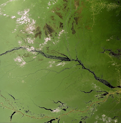
Amazon Basin, Brazil, South America


A large part of Brazil's Amazon Basin is shown here. The area is a low-lying valley almost entirely covered by tropical rainforest, criss-crossed by rivers including the mighty Amazon itself.

At first glimpse there appears to be no trace of mankind in this image, but a careful look reveals settlements and roads extending from top to bottom along the right hand side.

The Amazon River is the world's largest in terms of volume of water reaching the sea. The river's network also forms the world's largest drainage system, with around 1100 river tributaries. These tributaries are often referred to as 'white' or 'black' rivers. White rivers (their actual colour is yellowish) often rise in the Andes, their tint resulting from heavy loads of mud and silt. Black rivers, conversely, rise in rocky basements from where little or no sediment is carried along.

A beautiful example of the confluence of the Basin's main white and black rivers, the Solim es and the Rio Negro converging on the Amazon River, can clearly be seen.

A peculiarity of the Amazon is the lack of settlements along the river's banks, compared to the usual large ports, transport networks and industrialised cities found along important waterways. Among the only three sizable cities settled on the Amazon banks is Manaus on the right of the image, just north of the confluence.

Rainforests worldwide are being destroyed at an alarming concern, a development of great concern because they are essential to life on a global scale. Unlike other forests, rainforests do not grow back when they are destroyed and their soils are not suitable for continued agricultural use.

All countries in the Amazon region are now looking into ways of exploiting its natural resources in a sustainable manner without destroying the rainforest any further. Environmentalists and Indians are working together to create markets for products such as nuts, fruits, oils and pigments.

This image was acquired by Envisat's Medium Resolution Imaging Spectrometer (MERIS) on 4 October 2002, working in Full Resolution Mode providing 300 metre resolution.

Thursday, September 1, 2011

Nova Scotia, Canada


This Envisat image highlights the Canadian province of Nova Scotia, located on the eastern seaboard of North America. The province is made up of a mainland peninsula and Cape Breton Island (located to the east).

Nova Scotia is one of Canadas three Maritime provinces along with New Brunswick (visible in the upper left hand corner) and Prince Edward Island (visible to the east of New Brunswick, partially cloud-covered).

The Gulf of St. Lawrence is visible above Prince Edward Island, and the Northumberland Strait is visible between New Brunswick and Prince Edward Island. The Atlantic Ocean is visible to the south and east of the peninsula, and the Bay of Fundy is visible between the peninsula and New Brunswick.

With an area of 55 284 sq km, Nova Scotia is Canadas second smallest province, after Prince Edward Island. The main peninsula is 550-km long and has 7500 km of coastline. Because the province is not more than 130 km wide, no place in Nova Scotia is far from the sea.

This image was acquired by Envisat's Medium Resolution Imaging Spectrometer (MERIS) instrument on 22 October 2007, working in Full Resolution mode to provide a spatial resolution of 300 metres.

Fires and floodplains, Sudan, Africa


Numerous smoke plumes from burning fires are shown over southern Sudan in this Envisat image. Although the cause of these fires is unknown, agricultural fires in the region are common this time of year because the dry season begins in November. Deliberate fires are often set to burn out papyrus plants so grass can grow and feed livestock.

The Sudd (the lush green area running from the top left to the bottom centre of the image) is a network of channels, lakes and swamps. The size of France, it is one of Africas largest floodplains and provides watering and feeding grounds for many endemic mammals and birds as well as for large populations of migratory species.

The Sudd is created by the White Nile, which along with the Blue Nile forms the worlds longest river the Nile. The White Nile, also known in various sections as the Bahr-el-Abiad, Bahr-el-Jebel, Albert Nile and Victoria Nile, rises in the headwaters of Lake Victoria and runs through Uganda before entering Sudan and creating the Sudd. The Blue and White Nile Rivers come together in the north at Khartoum, Sudan's principal agricultural area.

For thousands of years the source of the Nile remained a mystery despite extensive efforts by the Greeks and Romans to locate it. The Sudd played a major role in keeping the origins of the Nile a mystery because explorers were not able to navigate through its swampy marshes. In 1858 British explorer John Hanning Speke became the first European to identify Lake Victoria as the Niles source.

Plans for the White Nile to bypass the Sudd to allow more water to reach the river downstream in the deserts of northern Sudan and Egypt resulted in the Jonglei canal. Construction began on the canal in 1978 but was suspended in 1983. Many conservation groups oppose the canal saying it will be disadvantageous to the areas indigenous tribes and wildlife.

This image was acquired on 11 December 2006 by Envisats Medium Resolution Imaging Spectrometer (MERIS) instrument while working in Full Resolution mode.

Wednesday, August 31, 2011

Mekong Delta, Vietnam


This Envisat image features Vietnam's Mekong Delta where the Mekong, the world's 12th longest river, fans out into tributaries and empties into the South China Sea in Southeast Asia.

Stretching from the glaciers of the Tibetan Qinghai Plateau to the South China Sea, the Mekong River flows some 4000 km through six nations China, Myanmar (Burma), Laos, Thailand, Cambodia and Vietnam.

In addition to 1500 species of fish, the river is home to the Mekong giant catfish, which can reach a length of three metres and weigh up to 300 kg. It also hosts the endangered Irrawaddy Mekong dolphin.

The 475 000 cubic km of water that the river discharges each year supplies the Mekong Delta's tropical wetlands with rich alluvial deposits. The wetlands act like sponges by storing and releasing water, making it ideal for rice cultivation.

In fact, such an enormous amount of rice is produced in the Mekong Delta that it is often referred to as Vietnam's 'rice bowl'. The rice grown there feeds the rest of the country and produces enough to make Vietnam the world's third biggest rice exporter, after Thailand and India.

Radar sensors, such as Envisats Advanced Synthetic Aperture Radar (ASAR), are particularly suited for monitoring rice cultivation because they are able to detect waterlogged ground and penetrate the humid cloud coverage typical of Asian rice-cultivating regions.

Ho Chi Minh (formerly known as Saigon), Vietnams largest city and chief port, is visible as white in the upper right corner.

The image was obtained by combining three ASAR acquisitions (9 January 2007, 13 February 2007 and 20 November 2007) taken over the same area. The colours in the image result from variations in the surface that occurred between acquisitions.

Istanbul, Turkey


The city of Istanbul, located astride the eastern edge of Europe and western edge of the Asian continent, shown in an Envisat radar multi-temporal composite image.

What is today Europe's third largest urban centre has been a major city for the last two thousand years. It has known three different names in that time: Byzantium when it was the gateway to Greek settlements on the Black Sea, Constantinople when it became the capital of the Eastern Roman Empire, then Istanbul when it fell to Muslim invaders in 1453.

In 1919 Istanbul lost its position as capital of Turkey, but remains that country's leading economic centre. Its population has grown from 2.84 million in 1970 to around ten million today, with settlers flocking from rural areas of Anatolia. Around 30% of all the cars owned in Turkey are in Istanbul.

Urban areas show up as white in this image the brightest areas being the most densely built-up. Among the densest is the old town, located on the west side of the city on the Emin�nu Peninsula, below the river estuary known as the Golden Horn. Further west along the coast are the runways of Ataturk International Airport.

Istanbul owes its prosperity to its status as a link between the Balkans, the Middle East and Central Asia, and to the high level of shipping that travels through the narrow Bosporus (Bosphorus) channel dividing Europe and Asia.

Some 48 000 ships pass through the Bosporus annually, three times denser than the Suez Canal traffic and four times as dense as the Panama Canal. Around 55 million tonnes of oil are shipped through here each year. Look closely along the Bosporus and bright points from individual ships can be seen. Also visible are the two bridges connecting the two continents, crossed by at least 45 000 vehicles daily.

Note the chain of islands known as the Princes' Islands (Kizil Islands) off the east side of Istanbul. The city faces onto the inland Sea of Marmara (Marmara Denizi), which has an area of around 11 350 square kilometres. The Bosporus links the Sea to the Black Sea. Note also Lake Iznik (Iznik Golu) towards the south-east corner of the image.

Because radar images measure surface texture rather than reflected light, there is no colour in a standard radar image.

Instead the colour in this image is due to it being a multitemporal composite, made up of three Advanced Synthetic Aperture Radar (ASAR) images acquired on different dates, with separate colours assigned to each acquisition to highlight differences between them: Red for 31 July 2003, Green for 17 April 2003 and blue for 26 February 2004.

The view was acquired in ASAR Image Mode Precision, with pixel sampling of 12.5 metres.

Tuesday, August 30, 2011

Canada's Maritime Provinces


This Envisat image highlights Canada's three Maritime Provinces New Brunswick, Nova Scotia and Prince Edward Island.

New Brunswick (the northern area of the large mass of land left of image centre) forms the land bridge linking this region to continental North America. It is bounded in the north by Qu bec and in the west by the US state of Maine (the southern area of the large land mass, visible).

With an area of approximately 73 440 sq km, New Brunswick is the largest of the provinces. New Brunswick differs from the other provinces because it is not wholly or nearly surround by water, making it sheltered from the Atlantic Ocean proper.

With an area of 55 284 sq km, Nova Scotia (the elongated body of land in bottom right) is Canada's second smallest province. The main peninsula is 550-km long and has 7500 km of coastline. Prince Edward Island (visible to the east of New Brunswick) is the smallest of the provinces.

The Gulf of St. Lawrence (visible above Prince Edward Island) is the outlet of North America's Great Lakes via the Saint Lawrence River into the Atlantic Ocean.

This image was acquired by Envisat's Medium Resolution Imaging Spectrometer (MERIS) instrument on 25 May 2008, working in Full Resolution mode to provide a spatial resolution of 300 metres.

The Caspian Sea


The shallow northern section of the Caspian Sea is shown in this Envisat image. Variously classed as an enormous lake or the smallest full-fledged sea, the Caspian is the largest landlocked water body in the world, with a surface area of 371 000 square kilometres.

The Caspian Sea is bordered by Russia, Azerbaijan, Iran, Turkmenistan and Kazakhstan. Stretching 1200 km from north to south, the almost-tide-free Caspian Sea fills a deep depression between Europe and Asia, its water level reaching around 28 metres below global ocean level. Its waters are not freshwater but salty although only about a third as much as true seawater. Its salinity is an inheritance from its origin as a remnant of the ancient Tethys Sea.

The northern part of the Caspian Sea is the most shallow, averaging about 10 metres deep, although its depth can shift by up to two metres, depending on variations in river flow and wind-driven currents. It appears bright blue here, probably due to a mixture of plant life and sediment stirred up by moving water.

This part of the Sea is also the location of vast oil and gas reserves, and the subject of major exploration and exploitation efforts, centred on the town of Atyrau at the mouth of the Ural River.

Around 130 rivers discharge into the Caspian, supplying around 300 cubic kilometres of freshwater annually. The two most significant rivers are both visible here. The Delta of the Volga River is visible in the left part of the image, while the Ural River can be seen flowing down from the image top centre. The Volga River is the longest in Europe, draining 20% of European land area and supplying 80% of the Caspian's freshwater inflow. The Ural River supplies 5% of its inflow.

The Sea's enclosed nature has enabled the preservation of some unique animals and plants. It also means that pollutants from industry and agriculture are concentrated within its brackish waters, threatening what are otherwise rich fisheries: the Caspian Sea is home to 85% of the world's stock of sturgeon and is the source of 90% of all black caviar. The Russian city of Astrakhan, located on the Volga Delta, remains at the centre of the caviar trade.

Along with increasing pollution, the Caspian Sea has also seen its water level fluctuate in past decades, at least partly due to human activity. As dams were constructed on rivers feeding the Sea its water level fell during the 1960s and 1970s, leading to construction on newly exposed shorelines. But since the late 1970s the water level began to rise again and has now risen by around 2.5 metres. Today it has stabilised and may even be falling again.

This image was acquired by the Medium Resolution Imaging Spectrometer (MERIS) instrument on Envisat on 22 September 2003, working in full resolution mode at 300 metre resolution.

Monday, August 29, 2011

Benelux and the English Channel


The green landscapes of Belgium, the Netherlands and Luxembourg, collectively known as Benelux, as seen by Envisat, along with a corner of France and the south-east coast of the United Kingdom across the English Channel (La Manche).

The collective term Benelux - from the first letters of each nation, originated from the Benelux Economic Union, which entered force in 1948 but has since been superseded by the European Union it helped inspire.

The three countries have a combined population of 27 million people, living in fertile, low-lying territory. Grey pixels seen on the image correspond to built-up areas; Benelux is the most densely populated region in Europe.

The most easterly country in the image is the Netherlands, located at the mouths of three major European rivers: the Rhine, the Meuse (Mass) and the Schelde, the latter just across from the Belgian border.

Clearly visible on the coast is the westerly section of the Waddenzee (Wadden Sea), a body of water and associated wetlands extending into Germany. Directly south of the Waddenzee are the IJsselmeer and Markermeer freshwater lakes. At the southern tip of the Markermeer is Amsterdam, with The Hague and Rotterdam further along the coast.

Just north of The Hague in the coastal town of Noordwijk is located ESA's European Space Technology Research Centre (ESTEC), where Envisat was designed, integrated and tested before being flown to French Guiana for launch in March 2002.

South of the Netherlands is Belgium, with the major cities of Antwerp and Brussels visible along with multiple settlements including Charleroi and Namur along the course of the Sambre River.

Directly east of southern Belgium is the small land-locked nation of Luxembourg, located within the darker greenery of the Ardennes, a region of dense forests and rolling hills.

Towards the western edge of the image we enter the Pas-de-Calais department in northern France, including the coastal cities of Calais and Dunkirk. Across the Channel is located the UK port of Dover. Sedimentary outflow from the River Thames is clearly seen - the same phenomena can be seen at smaller scales at the other river mouths in the image.

This 14 July 2003 image was acquired by Envisat's Medium Resolution Imaging Spectrometer (MERIS) in Full Resolution mode. It has a spatial resolution of 300 metres and covers 672 x 672 kilometres.

Bloom in the Baltic Sea


A colourful summer marine plankton bloom fills much of the Baltic Sea in this Envisat image.

Plankton are microscopic marine plants that drift on or near the surface of the sea, by far the most abundant type of life found in the ocean. Just like plants on land they employ green-pigmented chlorophyll for photosynthesis - the process of turning sunlight into chemical energy.

While individually microscopic, plankton chlorophyll collectively tints the surrounding ocean waters, providing a means of detecting these tiny organisms from space with dedicated 'ocean colour' sensors.

As if dye had been placed in the water, the greenish colour highlights whirls of ocean currents. Floating freely in the water, plankton are sensitive not just to available sunlight but also to local environmental variations such as nutrient levels, temperature, currents and winds. Favourable conditions lead to concentrated 'blooms' like the one we see here.

Monitoring plankton is important because they form the base of the marine food web sometimes known as 'the grass of the sea'.

On a local level, out-of-control blooms can devastate marine life, de-oxygenating whole stretches of water, while some species of phytoplankton and marine algae are toxic to both fish and humans. It is useful that fishermen, fish farmers and public health officials know about such events as soon as possible.

Globally, plankton are a major influence on the amount of carbon in the atmosphere, and hence need to be modelled into calculations of future climate change.

Such blooms are common at this time of year in the Baltic Sea due to the combination of warm weather and waters rich in phosphorous nutrients. This phosphorous comes from the sea floor, having been released for surface layer plankton to consume when autumn and winter storms mix the water mass at the start of 2005 a severe storm caused mixing in a deep column of water.

The bloom seen here stretches around 200 kilometres from Lithuania, Latvia and the Russian territory of Kalingrad to the Swedish coast, surrounding the Swedish islands of Gotland and land. Blooms in the Baltic Sea are routinely monitored by the Finnish Environmental Institute (SYKE).

Envisat's Medium Resolution Imaging Spectrometer (MERIS) instrument is optimised for ocean colour detection, but also returns detailed multispectral information on land cover, clouds and atmospheric aerosols.

MERIS acquires continuous daytime observations in Reduced Resolution mode as part of its background mission. This is a detail from a MERIS Reduced Resolution image acquired on 13 July 2005, with a spatial resolution of 1200 metres.

Saturday, August 27, 2011

The Middle East


This Envisat image shows the blue eastern edge of the Mediterranean and the desert landscape of the Middle East.

The territory of numerous nations is covered, including Israel, Lebanon and Syria on the coast, Jordan to the east of Israel, and part of Saudi Arabia and Iraq.

Prominent at the bottom left of the image is the Dead Sea. Located at 417 metres below sea level, the Dead Sea is the lowest point on the Earth's surface. With a surface area of 1050 square kilometres, this water body is ten times more salty than the open sea. This salinity is too much for any fish to survive, although bacteria and fungi are found in its waters.

The Dead Sea is divided between Israel and Jordan. Note the greenish area just south of the Sea: this is a large complex of Jordanian salt evaporation ponds used to produce sodium chloride and other salts for the chemical industry and human and animal consumption.

On either side of the northern edge of the Dead Sea can be seen grey areas indicating built-up areas: with Amman, the capital of Jordan, to its east and Jerusalem to its west. The town of Bethlehem is positioned south of Jerusalem, within the West Bank.

The water body north of the Dead Sea - connected to it by the Jordan River as it follows the course of the Great Rift Valley - is the Sea of Galilee, also known as Lake Tiberias. The settlement of Nazareth lies to its west.

At the top right of the image can be seen the green and fertile banks of the Euphrates River, running through Syria towards the Iraq border.

This 11 June 2003 image was acquired by the Medium Resolution Imaging Spectrometer (MERIS) on Envisat, operating in full resolution mode, with a resolution of 300 metres.

Friday, August 26, 2011

Lake Volta, Ghana, Africa


This is one of the largest artificial bodies of water in the world, as seen by ESA's Envisat from 800 kilometres away in space.

Lake Volta dominates the territory of the West African state of Ghana. Formed by the construction of the Akosombo Dam over the River Volta in the mid-1960s, it has an area of 8 482 sq km. Lake Volta is used to generate electricity and provide inland transportation, and its waters are also used for irrigation and fishing.

The image clearly illustrates the divide between the verdantly forested ''Ashanti' region in the southeast of the country and the sparser lowland savannah and plains to the north.

Towards the top of the plateau can be seen road networks leading to and from the settlement of Kumasi, Ghana's second city with a population of two thirds of a million. Southeast of Kumasi is the circular Lake Bosumtwi, a flooded meteorite crater - in fact one of only 18 confirmed African impact craters.

On the coast of the Gulf of Guinea, south of Lake Volta, is located the sprawling capital Accra, Ghana's largest city with approximately 1.6 million inhabitants.

This 12 February 2003 image was acquired by the Medium Resolution Imaging Spectrometer (MERIS) instrument on Envisat, working in Full Resolution mode. The image has a resolution of 300 metres and covers 450 km by 670 km.

Brazil's Amazon Basin, South America


The eastern part of Brazil's Amazon Basin and rainforests, located in the state of Par , is highlighted in this Envisat image.

The Amazon Basin is drained by the Amazon River, located to the east (not visible), and its tributaries. The brownish sediment-laden water visible flowing at the top of the image is the Par� River, the southern arm of the mouth of the Amazon.

Belem (barely visible to the right of the Par� in the upper left), the state capital of Par�, is located on the Par� Rivers south bank.

Dark river waters visible flowing just under the Par� belong to the Tocantins River, which runs roughly 2500 km from south to north. The large dark area visible in the image centre is the reservoir that was formed by the Tucurui dam on the Tocantins River, flooding some 2430 km� of forestland.

This image clearly highlights the contrast between the rainforest (dark green areas) and sprawling land cultivation (the fishbone-like patterns). Light green colours indicate agricultural areas which where covered by rainforest before.

Rainforests worldwide are being destroyed at an alarming rate, a development of great concern because of the role they play in global climate and because they are home to nearly half of the worlds species of plants, animals and insects. Unlike other forests, rainforests do not grow back when they are destroyed and their soils are not suitable for long-term agricultural use.

All countries in the Amazon region are now looking into ways of exploiting its natural resources in a sustainable manner without destroying the rainforest any further. Environmentalists and Indians are working together to create markets for products such as nuts, fruits, oils and pigments.

With their unique view from space, Earth observation satellites have been instrumental in highlighting the vulnerability of the rainforests by documenting the scale of deforestation, particularly in remote areas.

This image was acquired by Envisat's Medium Resolution Imaging Spectrometer (MERIS) on 23 June 2008, working in Full Resolution Mode providing a spatial resolution of 300 m.

Thursday, August 25, 2011

Lake Mead, Nevada-Arizona, USA


This Envisat image features the manmade Lake Mead, located east of Las Vegas (visible) and west of the Grand Canyon along the border of the US states of Arizona (bottom, east of river) and Nevada (the rest).

The 20th century was the great age of dam building, which did more to change the face of our planet than any other single human activity. Lake Mead was established in the early 1930s by the construction of the Hoover Dam on the Colorado River (bottom).

The Hoover Dam (green area between the lake and river) was one of the first of some 45 000 major dams to be constructed on rivers worldwide. It controls the flow of the Colorado, irrigates farmlands and supplies hydroelectric power and dependable water to people in the southwestern US and northern Mexico.

Its reservoir, Lake Mead, is one of the largest in the world, with a surface area of 593 sq km. However, an 11-year drought and increased water consumption due to population growth have resulted in a decline in its water levels. This month, it fell to its lowest point (330 m above sea level) since it was filled 75 years ago.

With some 90% of southern Nevadas water coming from the lake, authorities are watching its levels closely. If the water level dips to 327 m, a shortage will be declared and a set of rationing measures will be implemented.

This image was created by combining three Envisat radar acquisitions (15 May, 19 June and 24 July 2010) over the same area. The colours result from changes in the surface that occurred between acquisitions.

Wednesday, August 24, 2011

Salty plain, Bolivia, South America


This Envisat image features salt flats in the Department of Potosi in southwest Bolivia, near the crest of the Andes Mountains.

The Salar de Uyuni (the lower white area) is the largest salt flat in the world, occupying 10 582 sq km. It is located at the southern end of the Altiplano, a high plain of inland drainage in the central Andes.

Some 40 000 years ago, this area was part of a giant prehistoric lake that dried out, leaving behind two salt flats, the Uyuni and the Salar de Coipasa (visible above Uyuni), as well as two modern lakes, Poop (visible in green) and Uru Uru.

Occupying 2218 sq km, Salar de Coipasa is Bolivia's second largest salt flat.

Stretching 90 km in length and 32 km in width, Lake Poop� is the country's second largest lake with the permanent part of its body covering approximately 1000 sq km.

This image was acquired by Envisats Medium Resolution Imaging Spectrometer (MERIS) instrument on 7 May 2008 working in Full Resolution mode to provide a spatial resolution of 300 m.

Lake Tana, Ethiopia, source of the Blue Nile


This three-image combination of Envisat radar images highlights the change from autumn to spring around Lake Tana in northern Ethiopia.

With a surface area of 2156 square kilometres but an average depth of only 14 metres due to high levels of sediment. Lake Tana is the largest single lake in Ethiopia and forms the main reservoir for the Blue Nile. The Lake is located at an altitude of 1788 metres on the north central plateau of Amhara.

Lake Tana is used for fishing, farming and transportation, and has a thriving tourist industry centred on the more than 30 islands on the Lake, home to numerous Ethiopian Orthodox Church monasteries dating back more than five centuries.

The Blue Nile runs from Lake Tana's southeast corner, flowing south over a lava dam to form the Tisisat Falls - the name in Ethiopian means 'the water that smokes' - then flowing northwest to merge with the White Nile and form the full-fledged Nile itself. The Blue Nile contributes two thirds of all the Nile discharge, along with most of the sediment carried along 4750 kilometres through to Egypt and the Mediterranean.

To the northeast of the lake is Simen Mountains National Park, a UNESCO World Heritage Site. These jagged mountain peaks and deep gorges are home to a number of rare animals including the Gelada baboon and Walia ibex, a type of goat.

Radar images measure surface roughness rather than reflected light, so the smooth Lake waters are as distinctive as the harsh landscape around it. The colour in the image comes from the fact that this is actually a combination of three Envisat Advanced Synthetic Aperture Radar (ASAR) images, and is used to highlight changes occurring between acquisitions.

A colour is assigned to each date of acquisition: red for 3 September 2003, green for 27 November 2003 and blue for 4 March 2004. The images were acquired in wide swath mode, covering an overall span of 400 km.

Tuesday, August 23, 2011

Vancouver and Seattle, Pacific Northwest


Vancouver and Seattle, the two major port cities of the American Pacific Northwest, nestle in sheltered sea channels flanked by snow-covered mountains in this Envisat image.

Vancouver is the largest port in Canada, with an overall metropolitan area population of two and a half million. It is located towards the centre of the image, on the Strait of Georgia, a body of water shielded from the Pacific by the bottom end of Vancouver Island. Look closely to see a greenish-black grid pattern covering the flat terrain.

Around Vancouver the Coast Mountains to the north turn into the Cascade Mountains when south of the United States border, just below the city of Vancouver itself. On the other side of the mountains the flat, dry wheat prairies begin.

The United States port of Seattle is to be found some way below Vancouver towards the southern end of the sheltered channel, between the east side of Puget Sound and Lake Washington. It is a major economic centre, with an overall metropolitan area of about 3.7 million people.

Facing Seattle to the west is the snowy, forested Olympic Peninsula, topped by Mount Olympus. To its south is found Mount Rainier, a dormant volcano clad with glaciers, and the tallest peak of the Pacific Northwest.

This 15 February 2005 Medium Resolution Imaging Spectrometer (MERIS) image was acquired in Full Resolution Mode, providing a spatial resolution of 300 metres and covering a width of 672 kilometres.

Dongting Lake and the Yangtze River, China


China's longest river and its second largest lake are central features of this Envisat Advanced Synthetic Aperture Radar (ASAR) image.

Dongting Lake is the large L-shaped body of water, seen towards bottom right in the image. It - and the Central Yangtze region in general - is an important habitat for numerous aquatic species including the Yangtze freshwater dolphin. Dongting's total area varies considerably as Yangtze flood waters pour into the lake between July and September, the period within which this image was acquired.

Dongting's official area is 2740 square kilometres, less than half the 6200 square km size it was measured at a century and a half previously its size having been reduced by rapid sedimentation and reclamation for farmland.

In winter this shrinkage means the lake is more or less split into three separate basins, West, South and East Dongting, but each summer the three water bodies become a single lake of about 3900 square km or more.

Several rivers join onto Dongting Lake, the most famous being the Yangtze, winding down from towards top left before carrying on out of the right side of the image. Note the several oxbow lakes formed on its right bank. The Yangtze is the longest river in Asia and the third longest in the world, snaking for 6300 km across China and serving as a drain for 1.8 million square km of territory.

Also feeding into Dongting Lake are rivers including the Yuan, coming from the left, Yiang, from the bottom, and Zi, lying between them.

The heart-shaped water body above the Yangtze to the right side of the image is Lake Hong, known across the country for its beauty and significant as a site for fishing and crab breeding.

This image is a 240-km wide section from an ASAR Wide Swath image acquired 16 August 2003.

Monday, August 22, 2011

Gulf Of Oman, dust storm


This image is dominated by a dust and sand storm covering up the Gulf of Oman.

The scene shows a large part of Baluchistan, a mountainous region, with some deserts and barren plains, covering southwestern Pakistan and southeastern Iran (top right top center).

More towards the east, the Indus river providing irrigation to the valley plains, and throwing itself into the Arabian Sea about 100km southwest of Karachi, Pakistans largest city and chief port. The top right area of the image shows a part of the Thar Desert also known as the Great Indian Desert.

The Thar Desert is located in east Pakistan and northwest India and is bounded by a salt marsh called Rann of Kutch on the south. Soutwest of the image is the Arabian Peninsula completely covered under a veil of dust and sand, just as the Gulf of Oman, the principal vain for oil tankers from the nations around the Persian Gulf.

The dust and sand are transported for over 450 km off the coast. This kind of storm is a regular phenomenon in the area, which is usually due to very strong Shaman winds. The storms do not only interrupt daily life, they cause havoc, and present a danger for health and food security.

The frequency of the storms may be influenced by human activity, through heavy drainages in arid environments.

This Envisat Medium Resolution Imaging Spectrometer (MERIS) image was aquired on 13 December 2003 working in full resolution mode to provide a spatial resolution of 300 metres.